About Nujiang 72 Turns
The Nujiang 72 Turns — known in Chinese as "怒江七十二拐" — is arguably the single most legendary, feared, and visually spectacular stretch of highway on the entire 2,146-kilometer Sichuan-Tibet Highway (G31...
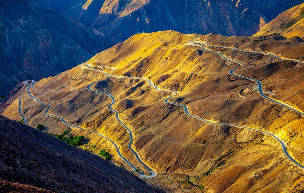
The Nujiang 72 Turns — known in Chinese as “怒江七十二拐” — is arguably the single most legendary, feared, and visually spectacular stretch of highway on the entire 2,146-kilometer Sichuan-Tibet Highway (G318). Located between the towns of Bangda and Basu in Nyingchi Prefecture, this jaw-dropping sequence of relentless, hairpin switchbacks zigzags violently down from the Yela Pass at 4,658 meters to the scorching floor of the Nujiang (Salween River) gorge at just 3,100 meters — a dizzying vertical descent of over 1,500 meters packed into roughly 30 kilometers of non-stop, dizzying curves.
Viewed from the designated observation deck near the summit, the entire road system reveals itself in all its terrifying glory: an endless, serpentine ribbon of asphalt coiling back and forth across the barren, treeless mountainside like the trail of a delirious giant serpent. Dozens upon dozens of impossibly tight U-turns stack on top of one another, each switchback carved precariously into the steep, loose-soil slope. The sheer visual impact of this engineering marvel — humanity’s stubborn defiance of gravity and geology — is overwhelming and breathtaking, a sight that has become one of the most iconic and widely shared images representing overland travel in Tibet.
Beyond its engineering spectacle, the 72 Turns corridor traverses an extraordinary range of climate zones within a single descent. At the Yela Pass summit, travelers are surrounded by frigid, windswept alpine tundra and occasional snow flurries, while the Nujiang gorge floor below simmers in a subtropical microclimate with cacti, dry scrubland, and sweltering temperatures. This extreme vertical climate compression — from winter to summer in under an hour’s drive — is a visceral, unforgettable demonstration of the Tibetan Plateau’s dramatic topographical power.
↺ History
The historical origins of the Nujiang 72 Turns are inseparable from the construction of the Sichuan-Tibet Highway itself — one of the most ambitious and monumental road-building projects in modern Chinese history. In the early 1950s, over 110,000 soldiers and civilian workers were mobilized to carve a motorable road through some of the most hostile terrain on Earth, connecting Chengdu in Sichuan Province to Lhasa, the capital of Tibet. The Bangda-to-Basu section, with its extreme altitude, near-vertical slopes, and notoriously unstable geology, presented one of the most formidable engineering challenges of the entire project.
The construction took place under unimaginably harsh conditions with minimal mechanization. Workers battled relentless blizzards, oxygen deprivation above 4,500 meters, avalanche-prone slopes, and frequent landslides. Simple hand tools, dynamite, and raw human willpower were the primary instruments used to hack this improbable road into the mountainside. The Nujiang 72 Turns section was among the most technically demanding stretches — engineers had to devise a radical series of switchbacks to overcome a vertical drop of over 1,500 meters across terrain that seemed to defy any possibility of road construction.
For decades after its completion, this section of the G318 remained an unpaved, single-lane track of loose gravel, crumbling edges, and zero guardrails — a road that tested the courage and skill of every driver who attempted it. In recent years, massive government investment has dramatically upgraded the road surface to smooth, two-lane asphalt with modern guardrails and comprehensive drainage systems. While immeasurably safer and more comfortable than its harrowing predecessor, the 72 Turns remain a formidable driving challenge that commands absolute respect and concentration from every traveler who traverses them.
Recommended Tours
View All
3 Days / 2 Nights ★ 4.8
3 Days Nyingchi Grand Canyon & Basum Tso Tour

6 Days / 5 Nights ★ 4.8
6 Days Tibet Panorama Tour with Nyingchi, Everest & Namtso
3 Days / 2 Nights ★ 4.8
3 Days Everest Base Camp Tour from Lhasa
How To Get There
The Nujiang 72 Turns are located between Bangda Township and Basu County in Nyingchi Prefecture, along the northern branch of the classic Sichuan-Tibet Highway (National Highway G318). The switchback section begins its descent from the Yela Pass (also known as Yelagala Pass, 4,658 meters) and terminates at the bridge crossing the Nujiang (Salween River) in the gorge below.
For overland travelers driving the G318 from Chengdu to Lhasa, the 72 Turns are an unavoidable and climactic section of the journey, typically encountered on the segment between the high-altitude town of Bangda (where the road forks between the northern and southern branches) and the pleasant riverside town of Basu. The descent from the Yela Pass to Basu town takes approximately 1.5 to 2 hours under normal conditions, though this can stretch considerably during adverse weather or behind slow-moving truck convoys.
There is a well-marked observation platform and parking area near the summit of the Yela Pass, offering the classic bird’s-eye panoramic view of the switchbacks cascading down the mountainside. Most travelers stop here for 15 to 30 minutes for photography before beginning the actual descent. The nearest towns offering proper accommodation, fuel, and dining are Bangda (to the west, basic facilities only) and Basu (to the east, with a wider selection of hotels and restaurants).
ⓘ Travel Tips
- Best Time to Visit: The safest and most visually rewarding periods are April through June and September through November . During these months, the roads are generally dry, visibility is excellent, and the switchbacks can be appreciated in their full, dramatic glory. The summer monsoon season (July-August) brings torrential rain, dense fog, frequent landslides, and dangerously slick road surfaces — conditions that transform the 72 Turns from merely intimidating into genuinely life-threatening. Winter (December-March) often brings ice and snow to the upper switchbacks near Yela Pass, making the road treacherous even for the most seasoned drivers.
- Driving Safety — Absolutely Critical: If you are self-driving, the 72 Turns demand your absolute maximum concentration. Drive slowly and steadily in low gear during the descent — never coast or ride the brakes continuously, as brake fade on this extended downhill is a real and potentially fatal risk. Honk loudly before every blind curve. Stay firmly in your lane; overtaking on the switchbacks is suicidal. If you feel fatigued or dizzy from altitude, pull over at a safe widening and rest. For those without extensive mountain driving experience, it is strongly recommended to hire a professional local driver rather than attempting this section yourself.
- Altitude at the Summit: The Yela Pass observation deck sits at 4,658 meters. Altitude sickness symptoms — headache, nausea, shortness of breath — can strike anyone at this elevation. Keep your stop at the summit brief (15-20 minutes), avoid running or jumping for celebratory photos, and have portable oxygen readily accessible. The good news is that the descent rapidly brings you to the much more comfortable elevation of Basu town at around 3,260 meters.
- Photography Tips: The absolute best time for photographing the switchbacks from the Yela Pass viewpoint is in the early morning , when the low-angle sunlight dramatically illuminates the curves against the deep shadows of the mountain. Overcast midday light tends to flatten the scene and reduce contrast. A wide-angle lens (16-35mm equivalent) is essential to capture the full scope of the switchbacks; a telephoto lens (70-200mm) is also useful for isolating individual dramatic curves with vehicles on them for a sense of scale. Drone photography is spectacular here but exercise extreme caution with the fierce, unpredictable summit winds.
- Road Conditions and Vehicle Requirements: The modern, upgraded road surface is now smooth asphalt throughout, and the switchbacks are navigable by standard sedans in good weather. However, a vehicle with reliable brakes, good tires, and preferably low-range gearing remains strongly advisable. Always check local road condition reports before departing — landslides can close sections temporarily, requiring detours via the less-traveled northern G317 route. Carry basic emergency supplies: snacks, water, warm clothing, a flashlight, and a portable phone charger, as mobile signal coverage is spotty throughout the gorge.
Enjoy Visa-Free Travel To China & Tibet
China has expanded visa-free entry policies for more countries. Our team can help confirm your route, permits, and documents before departure.
Gallery