About Bangda Grassland
Bangda Grassland (邦达草原), sprawling across the high-altitude basin where Chamdo and Nyingchi prefectures converge, is one of the largest and most pristine alpine meadow systems in all of eastern Tibet. Sitting ...
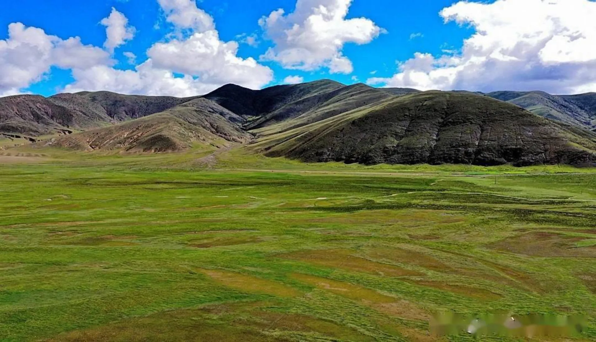
Bangda Grassland (邦达草原), sprawling across the high-altitude basin where Chamdo and Nyingchi prefectures converge, is one of the largest and most pristine alpine meadow systems in all of eastern Tibet. Sitting at an average elevation of 4,334 meters, this vast, seemingly limitless carpet of green stretches to the horizon in every direction, hemmed only by distant snow-dusted mountain ridges and an impossibly expansive cobalt sky. It is a landscape of profound, almost meditative emptiness — a place where the immense scale of the Tibetan Plateau reveals itself in its purest, most undiluted form.
The grassland is bisected by the gently meandering Yuqu River (玉曲河), whose countless silver tributaries braid and weave across the meadow like shimmering veins of mercury. In summer, the entire plain erupts into a breathtaking mosaic of wildflowers — golden buttercups, purple asters, crimson primulas, and delicate blue gentians — transforming the grassland into a living impressionist painting. Herds of yaks graze in dark, scattered clusters, and the black tents of Tibetan nomads dot the landscape, trailing thin wisps of juniper smoke into the crystalline air.
Bangda is also renowned as a critical habitat for one of Tibet’s most emblematic and endangered species: the black-necked crane. Every spring, these elegant, sacred birds migrate from their wintering grounds to breed on the marshy wetlands surrounding the Yuqu River. Watching a pair of black-necked cranes perform their graceful, synchronized courtship dance against the backdrop of snow-capped peaks and endless grassland is one of the most unforgettable wildlife encounters in all of the Himalayas.
↺ History
For centuries, Bangda Grassland has been the lifeblood of the Khampa nomadic herding communities who call this windswept plateau home. Unlike the settled agricultural societies of the Yarlung Tsangpo valley, the Khampa nomads of Bangda have maintained a traditional transhumant lifestyle — moving their yak and sheep herds between summer highland pastures and sheltered winter valleys in an ancient, carefully choreographed seasonal rhythm dictated by grass growth and weather patterns. Their distinctive black yak-hair tents, hand-woven over generations, remain a defining visual symbol of this grassland.
Geographically, Bangda has always occupied a position of immense strategic importance. It sits at the critical junction where the northern and southern branches of the Sichuan-Tibet Highway (G318) diverge — the northern route heading toward Chamdo and eventually Qinghai, and the southern route plunging dramatically down through the legendary Nujiang 72 Turns toward Basu and onward to Lhasa. This crossroads position meant that historically, Bangda was a vital rest stop and trading post on the ancient Tea Horse Road, where caravans from Sichuan, Yunnan, and central Tibet would converge to exchange tea, salt, wool, and horses.
In 1995, Bangda Airport (邦达机场) was constructed on the grassland’s flat expanse, becoming one of the highest commercial airports in the world at 4,334 meters. The airport’s construction was an extraordinary engineering feat — building a functional runway on frozen, oxygen-deprived terrain where temperatures plummet to minus 30 degrees Celsius in winter. Despite its extreme operating conditions, the airport has dramatically improved accessibility to eastern Tibet, connecting this remote grassland to Chengdu and Lhasa by air.
Recommended Tours
View All
6 Days / 5 Nights ★ 4.8
6 Days Tibet Panorama Tour with Nyingchi, Everest & Namtso
3 Days / 2 Nights ★ 4.8
3 Days Nyingchi Grand Canyon & Basum Tso Tour
3 Days / 2 Nights ★ 4.8
3 Days Everest Base Camp Tour from Lhasa
How To Get There
Bangda Grassland is located in the western portion of Basu County, Chamdo Prefecture, straddling the critical junction of the Sichuan-Tibet Highway (G318). It lies approximately 100 kilometers west of Chamdo city and about 95 kilometers west of Basu county town, making it a natural waypoint on any overland journey along the G318.
For self-drivers and tour groups traveling the Sichuan-Tibet Highway, Bangda is an unavoidable passage point. Heading westward from Chamdo, vehicles climb steadily onto the grassland’s expansive plateau before reaching the Bangda junction. Here, the road splits: the main G318 continues south, immediately beginning the legendary descent through the Nujiang 72 Turns toward Basu, while a northern branch heads toward Tengchen and the G317 route.
Bangda Airport (IATA: BPX), situated directly on the grassland, offers regular flights to Chengdu and Lhasa. However, due to the extreme altitude and volatile weather conditions, flight cancellations and delays are extremely common — travelers relying on air access should always maintain flexible schedules and backup plans. From the airport, Bangda town is just a few minutes’ drive, and onward road connections to Chamdo or Basu are straightforward along well-paved highways.
ⓘ Travel Tips
- Best Time to Visit: June through September is the golden window for experiencing Bangda Grassland at its finest. The meadows are lush and vividly green, wildflowers are in full bloom, nomadic families are actively herding across the landscape, and the weather is at its most tolerable. Outside this window, the grassland transforms into a harsh, frozen, monochromatic brown expanse battered by ferocious winds — visually dramatic in its own austere way, but bitterly inhospitable for leisurely exploration.
- Altitude Awareness: At 4,334 meters, Bangda sits at a significant elevation where oxygen levels are noticeably reduced. Most travelers passing through on the G318 are already somewhat acclimatized from days of gradual altitude gain, but if you are arriving directly by air via Bangda Airport, the immediate exposure to thin air can trigger acute altitude sickness. Take it extremely easy for the first few hours after landing — no heavy lifting, no running, and drink plenty of water. Portable oxygen is strongly recommended for airport arrivals.
- Nomadic Culture Etiquette: If you encounter nomadic families and their yak herds on the grassland, you are welcome to approach respectfully and observe, but always ask permission before photographing people, especially women and children. Tibetan nomads are generally warm and hospitable — if invited into a tent for butter tea, it is polite to accept at least a sip. Never drive your vehicle off the paved road onto the grassland itself, as this damages the fragile alpine turf that takes decades to recover at this altitude.
- Black-Necked Crane Viewing: If you visit between late April and early July, keep a sharp eye on the marshy wetland areas along the Yuqu River for black-necked cranes. These magnificent birds are a Class I protected species in China. Maintain a minimum distance of at least 300 meters when observing or photographing them — approaching too closely will frighten breeding pairs and potentially cause nest abandonment. A high-quality telephoto lens (300mm+) is essential for meaningful crane photography.
- Practical Considerations: Bangda town itself is a small, functional settlement with limited but adequate facilities — several basic guesthouses, a few Sichuan-style restaurants, fuel stations, and small convenience shops. It serves well as an overnight stop between Chamdo and Basu. Mobile phone signal (China Mobile has the best coverage) is available in town but drops out quickly on the open grassland.
Enjoy Visa-Free Travel To China & Tibet
China has expanded visa-free entry policies for more countries. Our team can help confirm your route, permits, and documents before departure.
Gallery