About Dongda La Pass
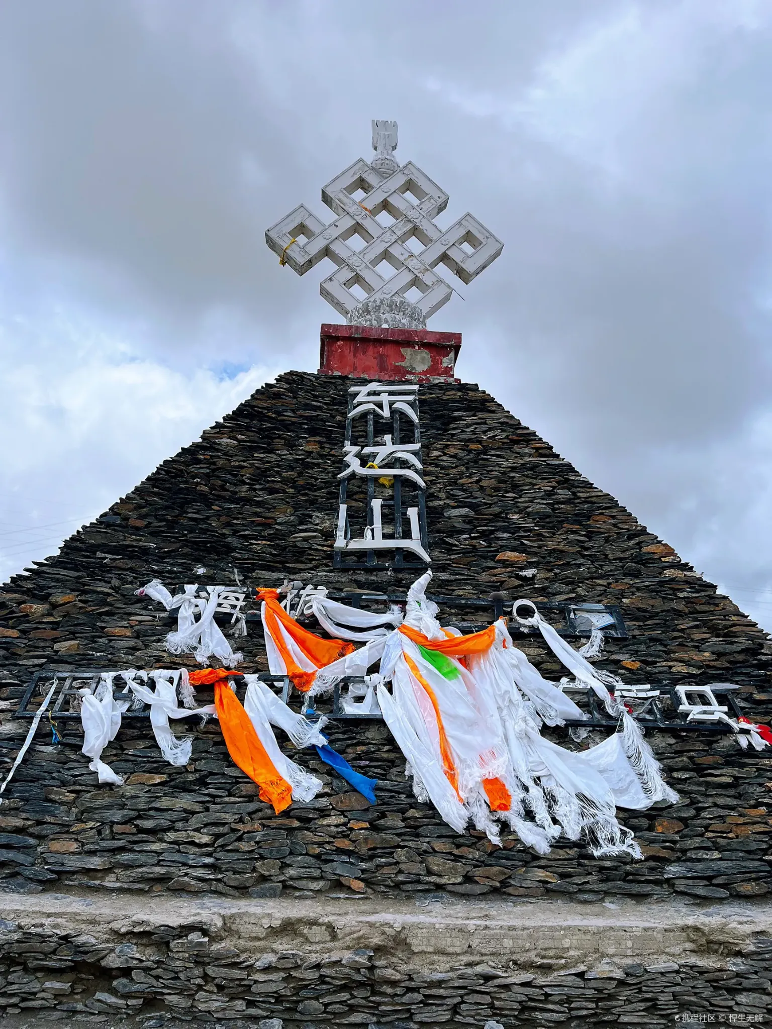
Dongda La Pass (东达山垭口), towering at a breathtaking 5,130 meters above sea level, is one of the highest points on the entire Sichuan-Tibet Highway (G318) and among the loftiest road passes that ordinary trave...
Dongda La Pass (东达山垭口), towering at a breathtaking 5,130 meters above sea level, is one of the highest points on the entire Sichuan-Tibet Highway (G318) and among the loftiest road passes that ordinary travelers will ever cross in their lifetime. Situated between the towns of Zogang and Zuogong (左贡) in Chamdo Prefecture, this colossal mountain barrier separates the watersheds of the Lancang River (Mekong) and the Yuqu River, serving as a dramatic geological boundary etched into the high Tibetan sky.
At the summit, the world is reduced to its most elemental components: a vast, barren moonscape of grey scree and frost-shattered rock extends in every direction, punctuated only by wind-tattered prayer flags, stone cairns draped in white khata scarves, and the occasional defiant patch of snow clinging to shadowed hollows even in midsummer. The air is brutally thin — containing barely half the oxygen found at sea level — and the silence is absolute, broken only by the relentless howl of the high-altitude wind. On clear days, the panoramic views from the pass are staggering: an infinite ocean of jagged, snow-frosted peaks stretching to the horizon, conveying the raw, overwhelming immensity of the Tibetan Plateau.
For countless overlanders traversing the G318, cresting Dongda La is a defining moment of the journey — a physical and psychological milestone that tests one’s endurance against the thin air while rewarding the spirit with a profound sense of standing on the roof of the world. The colorful summit marker stone, boldly engraved with the elevation “5,130m,” has become one of the most photographed landmarks on the entire Sichuan-Tibet route, a trophy shot that marks one’s conquest of this mighty pass.
↺ History
Dongda La has served as a critical high-altitude crossing point for centuries, long before the existence of any modern road. In ancient times, this towering pass was one of the most feared obstacles on the southern branch of the Tea Horse Road — the legendary trade network linking the tea-producing regions of Sichuan and Yunnan with the salt and wool markets of central Tibet. Yak caravans laden with compressed tea bricks would struggle for hours through knee-deep snow and oxygen-starved air to cross the pass, with traders relying on generations of accumulated knowledge about weather windows and safe crossing times.
The construction of the modern Sichuan-Tibet Highway through Dongda La in the 1950s was an extraordinary engineering endeavor. Road builders faced the combined challenges of permafrost, extreme altitude sickness, violent weather that could shift from sunshine to whiteout blizzard in minutes, and terrain consisting largely of unstable, frost-heaved loose rock. Carving a usable road across this frozen, crumbling landscape at over 5,000 meters required immense perseverance and ingenuity.
Even after the highway’s completion, Dongda La remained one of the most notoriously dangerous and unpredictable sections of the G318 for decades. Heavy snowfall could close the pass for days at a time during winter, stranding convoys of trucks and travelers on either side. In recent years, comprehensive road upgrades — including improved asphalt surfacing, reinforced retaining walls, and enhanced snow-clearing operations — have made the crossing significantly safer and more reliable year-round, though it still commands deep respect from every driver who tackles it.
Recommended Tours
View All
6 Days / 5 Nights ★ 4.8
6 Days Tibet Panorama Tour with Nyingchi, Everest & Namtso

3 Days / 2 Nights ★ 4.8
3 Days Nyingchi Grand Canyon & Basum Tso Tour
3 Days / 2 Nights ★ 4.8
3 Days Everest Base Camp Tour from Lhasa
How To Get There
Dongda La Pass is located on the Sichuan-Tibet Highway (G318) between Zogang (left bank of the Lancang/Mekong River) and the county seat of Zuogong in Chamdo Prefecture. The pass sits approximately 100 kilometers east of Zuogong town and roughly 75 kilometers west of Zogang town, forming an unavoidable high-altitude barrier on the classic southern Sichuan-Tibet overland route.
For travelers driving the G318 from east to west (Chengdu toward Lhasa), Dongda La is typically encountered after the dramatic descent through the Lancang River gorge from Zogang. The ascent begins gradually from the river valley floor at around 3,800 meters, steepening progressively as the road climbs through increasingly barren and treeless terrain. The final approach to the summit involves a series of sweeping curves across exposed, windblasted slopes before reaching the prayer-flag-adorned pass at 5,130 meters.
The total driving time from Zogang to Zuogong, crossing the pass, is approximately 3 to 4 hours under normal conditions. Most overland itineraries schedule Zuogong as the overnight stop after crossing Dongda La, as the town offers a reasonable selection of hotels and restaurants at a more comfortable altitude of around 3,750 meters. Travelers should be aware that the pass can experience sudden snowfall even in summer months, and winter crossings may require snow chains.
ⓘ Travel Tips
- Best Time to Cross: May through June and September through October offer the most stable weather and clearest visibility at the summit. July and August bring monsoon moisture that frequently shrouds the pass in dense cloud and fog, robbing you of the spectacular views. Winter crossings (November through March) are possible but risky — heavy snow, icy roads, and whiteout conditions are common, and the pass may be temporarily closed after major storms.
- Extreme Altitude — The #1 Concern: At 5,130 meters, Dongda La delivers a severe altitude punch. Even well-acclimatized travelers will feel noticeably breathless and lightheaded at the summit. Keep your stop at the pass as brief as possible — ideally no more than 10 to 15 minutes. Do not run, jump, or make any sudden, vigorous movements for celebratory photos. Have portable oxygen within arm's reach inside your vehicle. If any member of your group shows signs of severe altitude sickness (persistent vomiting, confusion, staggering gait), descend immediately without delay.
- Weather Preparedness: The temperature at the summit can be 15 to 20 degrees Celsius colder than the valley below, and the wind chill factor is savage. Even if you departed Zogang in warm sunshine and a T-shirt, have a heavy down jacket or insulated windbreaker ready to throw on the moment you step out of the vehicle at the pass. Gloves and a warm hat are not optional luxuries — they are necessities.
- Photography Tips: The iconic shot is a selfie or vehicle photo next to the summit marker stone with prayer flags and snow peaks in the background. Early morning crossings offer the most dramatic lighting. The actual summit area is relatively small and can become crowded with tour buses during peak season — arriving early gives you a better chance at an unobstructed photo. Be mindful of the wind when operating drones; the gusts at 5,130 meters are powerful and unpredictable.
- Vehicle Considerations: The modern road surface over Dongda La is well-paved asphalt, and the pass is navigable by standard vehicles in good weather. However, ensure your vehicle's engine is in good condition — the extreme altitude significantly reduces engine power output (by roughly 30-40% for naturally aspirated engines), and underpowered or poorly maintained vehicles may struggle on the final steep gradients. Keep your fuel tank at least half full before beginning the ascent, as there are no fuel stations between Zogang and Zuogong.
Enjoy Visa-Free Travel To China & Tibet
China has expanded visa-free entry policies for more countries. Our team can help confirm your route, permits, and documents before departure.
Gallery